Creator Record
Metadata
Name |
Cary, John |
Life Dates |
1754-1835 |
Nationality |
English |
Geographic location(s) |
London, England |
Occupation |
Cartographer, Engraver, Publisher |
Role |
Cartographer |
Related Records
-
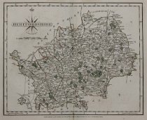
2014.21.63 - Map
John Cary Hampshire Hand-colored engraving London, 1787 Map with colored elements by John Cary: Hampshire, a county on the Southern coast of England in the United Kingdom. The regions, cities, towns, et cetera, are clearly identified on the map, larger settlements marked with castle/cathedral icon or green miniature park plan, i.e. "Dogmers field" top right of map. Borders, main roads, parks, and forests, colored, some texture, rivers, smal...
Record Type: Object
-
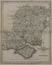
2014.21.64 - Map
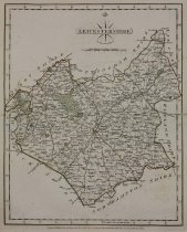
John Cary Hertfordshire Hand-colored engraving London, 1787 Map with colored elements by John Cary: Hertfordshire, a county in Southern England, bordered by Bedfordshire to the North, Cambridgeshire to the Northeast, Essex to the East, Buckinghamshire to the West, and Greater London to the South. The regions, cities, towns, et cetera, are clearly identified on the map, larger settlements marked with castle/cathedral icon or green miniature...
Record Type: Object
-
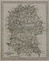
2014.21.65 - Map
John Cary Wiltshire Hand-colored engraving London, 1787 Map with colored elements by John Cary: Wiltshire, a county in Southwest England, bordered by Dorset, Somerset, Hampshire, Gloucestershire, Oxfordshire, and Berkshire. The regions, cities, towns, et cetera, are clearly identified on the map, larger settlements marked with castle/cathedral icon or green miniature park plan, i.e. "Swindon" top right of map. Borders, main roads, parks, an...
Record Type: Object
-
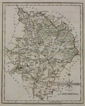
2014.21.66 - Map
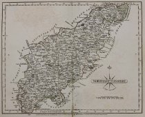
John Cary Northamptonshire Hand-colored engraving London, 1787 Map with colored elements by John Cary: Northamptonshire, county in the East Midlands of England, landlocked between eight other counties. The regions, cities, towns, et cetera, are clearly identified on the map, larger settlements marked with castle/cathedral icon or green miniature park plan, i.e. "Laxton Hall" middle right of map. Borders, forests, parks, main roads, and fiel...
Record Type: Object
-
2014.21.67 - Map
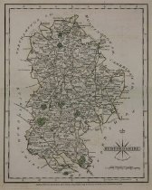
John Cary Bedfordshire Hand-colored engraving London, 1787 Map with colored elements by John Cary: Bedfordshire, a county in the East of England, bordered by Cambridgeshire to the Northeast, Northamptonshire to the North, Buckinghamshire to the West, and Hertfordshire to the Southeast. The regions, cities, towns, et cetera, are clearly identified on the map, larger settlements marked with castle/cathedral icon or green miniature park plan, ...
Record Type: Object
-
2014.21.68 - Map
John Cary Worcestershire Hand-colored engraving London, 1787 Map with colored elements by John Cary: Worcestershire, a county in West Midlands of England. The regions, cities, towns, et cetera, are clearly identified on the map, larger settlements marked with castle/cathedral icon or green miniature park plan, i.e. "Birmingham" top right of map. Borders, main roads, forests, parks, most field, colored, some texture, small roads, rivers, mou...
Record Type: Object
-
2014.21.69 - Map
John Cary Herefordshire Hand-colored engraving London, 1787 Map with colored elements by John Cary: Herefordshire, a county in the West Midlands of England, bordered by the English ceremonial counties of Shropshire to the North, Worcestershire to the East, Gloucestershire to the Southeast, and the Welsh preserved counties of Gwent to the Southwest, and Powys to the West. The regions, cities, towns, et cetera, are clearly identified on the m...
Record Type: Object
-
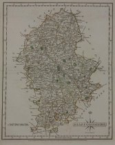
2014.21.70 - Map
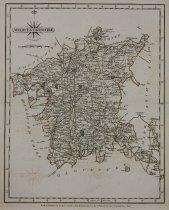
John Cary Staffordshire Hand-colored engraving London, 1787 Map with colored elements by John Cary: Staffordshire, a county in the West Midlands of England, bordered by Cheshire to the Northwest, Derbyshire and Leicestershire to the East, Warwickshire to the Southeast, West Midlands and Worcestershire to the South and Shropshire to the West. The regions, cities, towns, et cetera, are clearly identified on the map, larger settlements marked ...
Record Type: Object
-
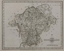
2014.21.71 - Map
John Cary Westmoreland Engraving London, 1787 Map with colored elements by John Cary: Westmoreland, an area of North West England and one of the 39 historic counties of England. The regions, cities, towns, et cetera, are clearly identified on the map, larger settlements marked with castle/cathedral icon or green miniature park plan, i.e. "Milbourn" top middle right of map. Borders, main roads, most fields, and parks, colored, some texture, ...
Record Type: Object
-
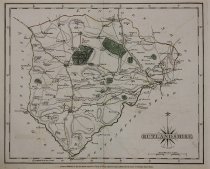
2014.21.72 - Map
John Cary Rutlandshire Engraving London, 1787 Map with colored elements by John Cary: Rutlandshire, a landlocked county in the East Midlands of England, bordered to the West and North by Leicestershire, to the Northeast by Lincolnshire, and the Southeast by Northamptonshire.The regions, cities, towns, et cetera, are clearly identified on the map, larger settlements marked with castle/cathedral icon or green miniature park plan, i.e. "Thisle...
Record Type: Object
-
2014.21.73 - Map
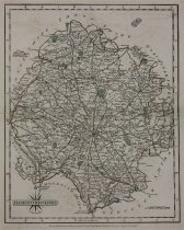
John Cary Huntingdonshire Hand-colored engraving London, 1787 Map with colored elements by John Cary: Huntingdonshire, a non-metropolitan district of Cambridgeshire and historic county of England. The regions, cities, towns, et cetera, are clearly identified on the map, larger settlements marked with castle/cathedral icon or green miniature park plan, i.e. "Fletton" top middle of map. Borders, main roads, forests, parks, and fields, colored...
Record Type: Object
-
2014.21.74 - Map
John Cary Warwickshire Hand-colored engraving London, 1787 Map with colored elements by John Cary: Warwickshire, a landlocked non-metropolitan county in the West Midlands region of England. The regions, cities, towns, et cetera, are clearly identified on the map, larger settlements marked with castle/cathedral icon or green miniature park plan, i.e. "Seekingdon" top middle of map. Borders, main roads, and parks, colored, some texture, small...
Record Type: Object

-
2014.21.75 - Map
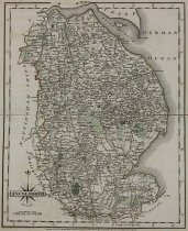
John Cary Lincolnshire Hand-colored engraving London, 1787 Map with colored elements by John Cary: Lincolnshire, a historical county in the East of England. It borders Norfolk to the Southeast, Cambridgeshire to the South, Rutland to the Southwest, Leicestershire and Nottinghamshire to the West, South Yorkshire to the Northwest, and the East Riding of Yorkshire to the North. The regions, cities, towns, et cetera, are clearly identified on t...
Record Type: Object
-
2014.21.76 - Map
John Cary Leicestershire Hand-colored engraving London, 1787 Map with colored elements by John Cary: Leicestershire, a landlocked county in the English Midlands, bordered by Nottinghamshire to the North, Lincolnshire to the Northeast, Rutland to the East, Northamptonshire to the Southeast, Warwickshire to the Southwest, Staffordshire to the West, and Derbyshire to the Northwest. The regions, cities, towns, et cetera, are clearly identified ...
Record Type: Object
-
2014.21.77 - Map
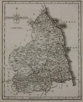
John Cary Northumberland Hand-colored engraving London, 1787 Map with colored elements by John Cary: Northumberland, a county in Northeast England, bordered by Cumbria to the West, County Durham to the South, and Scotland to the North. The regions, cities, towns, et cetera, are clearly identified on the map, larger settlements marked with castle/cathedral icon or green miniature park plan, i.e. "Howick" right middle of map. Borders, main ro...
Record Type: Object
-
2014.21.78 - Map
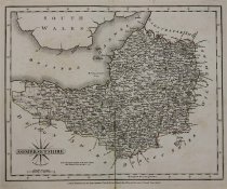
John Cary Somersetshire Hand-colored engraving London, 1787 Map with colored elements by John Cary: Somersetshire, a county in Southwest England, bordered by Gloucestershire and Bristol to the North, Wiltshire to the East, Dorset to the Southeast, and Devon to the Southwest. The regions, cities, towns, et cetera, are clearly identified on the map, larger settlements marked with castle/cathedral icon or green miniature park plan, i.e. "Cathe...
Record Type: Object
-
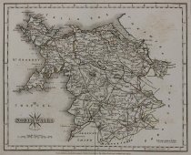
2014.21.79 - Map
John Cary North Wales Engraving London, 1787 Map by John Cary: North Wales, the Northernmost unofficial region of Wales, bordered to the South by the counties of Ceredigion and Powys in Mid Wales and to the East by the counties of Shropshire in the West Midlands and Cheshire in Northwest England. The regions, cities, towns, et cetera, are clearly identified on the map, larger settlements marked with castle/cathedral icon or green miniature ...
Record Type: Object