
Object Record
Images
Metadata
Catalog Number |
2014.21.68 |
Object Name |
Map |
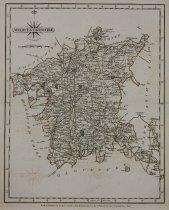
Description |
John Cary Worcestershire Hand-colored engraving London, 1787 Map with colored elements by John Cary: Worcestershire, a county in West Midlands of England. The regions, cities, towns, et cetera, are clearly identified on the map, larger settlements marked with castle/cathedral icon or green miniature park plan, i.e. "Birmingham" top right of map. Borders, main roads, forests, parks, most field, colored, some texture, small roads, rivers, mountain ranges, some fields, not colored, some texture. Decorative black and white title and credit cartouche with compass lines and fleur-de-lis, top left of map, scale below. Measurement marks surround black double line border, directional notation in English, "Longitude West from London", bottom right of map. Foxing spots scattered on surface, back, and toning around edges of map. Corners torn and bent. Text page attached to back of map, toning on edges. |
Title |
Worcestershire |
Date |
1787 |
Role of Creator |
Cartographer |
Creator |
Cary, John |
Medium |
hand color engraving |
Material |
paper |
Dimensions |
H-12 W-9.625 inches |
Credit line |
Gift of Jeffery M. Leving, Founder, Fathers’ Rights |
Place of Origin |
Europe/England/London |
Subjects |
England Worcestershire |