
Object Record
Images
Metadata
Catalog Number |
2014.21.76 |
Object Name |
Map |
Description |
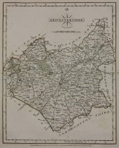
John Cary Leicestershire Hand-colored engraving London, 1787 Map with colored elements by John Cary: Leicestershire, a landlocked county in the English Midlands, bordered by Nottinghamshire to the North, Lincolnshire to the Northeast, Rutland to the East, Northamptonshire to the Southeast, Warwickshire to the Southwest, Staffordshire to the West, and Derbyshire to the Northwest. The regions, cities, towns, et cetera, are clearly identified on the map, larger settlements marked with castle/cathedral icon or green miniature park plan, i.e. "Stauton" top right of map. Borders, main roads, parks, and most fields, colored, some texture, small roads, rivers, and most fields, not colored, some texture. Decorative black and white title and credit cartouche with compass lines and fleur-de-lis, top middle of map. Measurement marks surround black double line border, directional notation in English, "Longitude West from London", bottom right of map. Foxing spots scattered on surface, back, and toning around edges of map, page creased, across middle of map, water damage, top and bottom right corners, paper damage, left and right of crease. Text page attached to back of map, toning on edges. |
Title |
Leicestershire |
Date |
1787 |
Role of Creator |
Cartographer |
Creator |
Cary, John |
Medium |
hand color engraving |
Material |
paper |
Dimensions |
H-12.25 W-9.625 inches |
Credit line |
Gift of Jeffery M. Leving, Founder, Fathers’ Rights |
Place of Origin |
Europe/England/London |
Subjects |
England Leicestershire |