
Object Record
Images
Metadata
Catalog Number |
2014.21.79 |
Object Name |
Map |
Description |
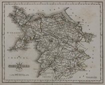
John Cary North Wales Engraving London, 1787 Map by John Cary: North Wales, the Northernmost unofficial region of Wales, bordered to the South by the counties of Ceredigion and Powys in Mid Wales and to the East by the counties of Shropshire in the West Midlands and Cheshire in Northwest England. The regions, cities, towns, et cetera, are clearly identified on the map, larger settlements marked with castle/cathedral icon or green miniature park plan, i.e. "Chester" top right of map. Most borders, main roads, and parks, colored, some texture, some borders, small roads, mountain ranges, rivers, and bodies of water, not colored, some texture. Decorative black and white title and credit cartouche with compass lines and fleur-de-lis, bottom left of map, scale below, note, bottom right of map. Measurement marks surround black double line border, directional notation in English, "Longitude West from London.", bottom right of map. |
Title |
North Wales |
Date |
1787 |
Role of Creator |
Cartographer |
Creator |
Cary, John |
Medium |
engraving |
Material |
paper |
Dimensions |
H-9.75 W-12 inches |
Credit line |
Gift of Jeffery M. Leving, Founder, Fathers’ Rights |
Place of Origin |
Europe/England/London |
Subjects |
Britain North Wales |