
Object Record
Images
Metadata
Catalog Number |
2014.17.49 |
Object Name |
Map |
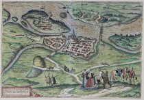
Description |
"Iaverinum vulgo Rab Anno 1594," Cologne, 1598, hand-colored engraving, map by Georg Braun, engraved by Frans Hogenberg. Probably from Civitates Orbis Terrarum, Cologne, Germany. A bird's-eye view of Györ in Hungary, which lies southeast of Bratislava at the confluence of the Raba and an arm of the Danube, clearly showing the bastioned fortifications and the bishop's palace (Palatium). The captions make reference to historical events. This bird's-eye view map depicts Györ, Hungary, which was laid ruin by the Ottomans when their empire stretched from Hungary to North Africa. Against the backdrop of burning buildings are (L to R): two heyducks, Hungarian mercenary soldiers; Hungarian noblewomen; a Polish knight with arrows in his side; and a captive Turkish soldier. The aerial view probably comes from Civitates Orbis Terrarum, an innovative book of maps of the world's cities, which was among the first to include aerial and linear perspective, important political events, and human figures meeting the viewer's gaze. |
Title |
Bird's-eye view of Györ, Hungary (Iaverinum vulgo Rab Anno 1594) |
Date |
1598 |
Role of Creator |
Cartographer |
Creator |
Braun, Georg |
Role of Creator 2 |
Engraver |
Creator 2 |
Hogenberg, Franz |
Role of Creator 3 |
Copy After |
Creator 3 |
Aginelli, N. |
Medium |
hand color engraving |
Material |
paper |
Dimensions |
H-16.375 W-21 inches |
Credit line |
Gift of Jeffery M. Leving, Founder, Fathers’ Rights |
Place of Origin |
Europe/Germany/North Rhine-Westphalia/Cologne? |
Subjects |
Cityscapes Map making Maps Mercenaries (Soldiers) Nobility Prisoners Prisoners of war Soldiers War |